
When Cities Turn Their Backs on Water
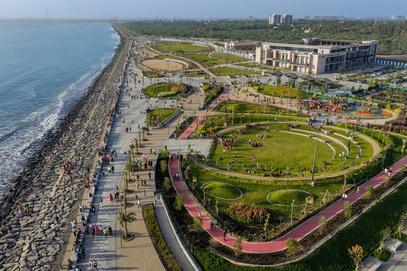
Across the projects we've covered this year, a recurring pattern emerges: cities that grew fastest during industrialisation often treated their waterfronts as service corridors rather than civic assets. Surat's Arabian Sea edge exemplifies this condition. Despite cultural ties to the Dumas coastline stretching back generations, the city's rapid expansion left the shoreline fragmented, underserved by infrastructure, and disconnected from the urban fabric it bordered. INI Design Studio's recently completed masterplan for the Dumas Sea Face confronts this legacy not through singular architectural gestures but through a strategy of continuity, ecological repair, and programmatic layering across 102 hectares.
The intervention, led by Harsh Goel, Jayesh Hariyani, and Pathik Gandhi, operates at the scale where landscape architecture, urban planning, and coastal engineering necessarily overlap. Rather than imposing a unifying formal language, the design establishes a continuous pedestrian realm that accommodates varied uses whilst maintaining ecological function along the littoral zone.
The Parti: Continuity Over Monumentality
The conceptual anchor of the masterplan lies in its insistence on uninterrupted public access. Where previous development had created isolated pockets of activity, the new intervention extends a linear promenade that runs the full length of the site, punctuated by nodes of programmed space but never severed by vehicular infrastructure or privatised enclaves. This decision reflects a deliberate rejection of the enclave model that has dominated Indian waterfront development over the past two decades, where gated leisure precincts replace genuinely public shorelines.
The promenade itself varies in width and character, responding to existing topography and ecological conditions. In sections where the dune ecology remains intact, the path retreats inland; where the shoreline had already been hardened, the design introduces vegetated buffers and permeable paving to mitigate stormwater runoff. This adaptive approach acknowledges that coastal resilience cannot be achieved through uniform treatment but requires calibrated responses to site-specific conditions.
Amit Mehta led the coordination between design and technical teams, ensuring that MEP systems, irrigation infrastructure, and structural interventions by Global Marine aligned with the overarching landscape strategy. The integration of these systems beneath the public realm, rather than as visible appendages, maintains the legibility of the site as a continuous ground plane rather than a collection of discrete infrastructures.
Material Palette and Vernacular Reference
The material strategy draws from regional construction traditions whilst accommodating the demands of high-traffic public space. Local stone varieties appear in seating elements and retaining walls, their thermal mass moderating surface temperatures in Surat's humid subtropical climate. Timber elements, treated for marine exposure, define pergola structures and boardwalk sections, introducing a tectonic contrast to the predominantly mineral palette.
Planting design, developed by the landscape architecture team, emphasises salt-tolerant native species capable of withstanding coastal exposure. Casuarina, Pandanus, and Calophyllum form the canopy layer, whilst lower strata incorporate grasses and shrubs that stabilise dunes and provide habitat structure. This is not ornamental landscaping but ecological infrastructure, designed to perform hydrological and microclimatic functions as much as aesthetic ones.
The decision to foreground planting over hardscape distinguishes this project from earlier Indian waterfront schemes that prioritised paved plazas and monumental lighting installations. Here, the landscape operates as the primary ordering system, with built elements subordinated to the ecological framework.
Precedents and Departures
The Dumas Sea Face invites comparison with recent coastal public space projects across Asia. Singapore's East Coast Park and Hong Kong's Tsim Sha Tsui Promenade established templates for linear waterfront parks in dense urban contexts, prioritising accessibility and programmatic flexibility. However, those projects emerged within highly controlled planning regimes and benefited from substantial reclamation that stabilised the land-water interface.
Surat's context differs significantly. The site lacks the infrastructural redundancy of Singapore or the topographic containment of Hong Kong's harbour edge. Instead, the masterplan confronts a dynamic coastline subject to monsoon surges and tidal variation, requiring design strategies that accommodate rather than resist hydrological flux. The integration of permeable surfaces, vegetated swales, and adaptive planting reflects an understanding of coastal processes that earlier Asian waterfront projects, conceived in more stable conditions, did not need to address.
Closer precedents might be found in recent Latin American coastal interventions, particularly in cities like Lima and Cartagena, where designers have grappled with similar challenges of fragmented shorelines, limited budgets, and the need to accommodate informal uses alongside programmed activities. The Dumas Sea Face shares with these projects an emphasis on incremental implementation and the acceptance of programmatic ambiguity, allowing uses to evolve rather than prescribing rigid functional zones.
The Politics of Public Space in a Growth City
Surat's designation as one of India's fastest-growing urban centres, according to census data, underscores the political dimension of this project. In cities experiencing rapid demographic and economic expansion, public space often becomes a contested resource, subject to pressure from commercial interests and incremental privatisation. The masterplan's success will ultimately be measured not by its initial completion but by its capacity to resist these pressures over time.
The decision to vest management responsibility within municipal agencies rather than private concessionaires represents a significant governance choice. Whilst this model introduces risks around maintenance capacity and budgetary continuity, it preserves the site's status as genuinely public infrastructure rather than a commercially operated amenity. This distinction matters in a country where waterfront development increasingly follows privatised models that restrict access through entry fees or selective programming.
The inclusion of diverse recreational facilities, ranging from children's play areas to informal gathering spaces, reflects an understanding that public space must accommodate varied constituencies simultaneously. The design avoids the mistake of mono-functional programming, which tends to produce spaces that are intensively used during narrow time windows and deserted otherwise. Instead, the layering of compatible activities across the site aims to sustain activity throughout the day and across seasons.
Technical Integration and Climate Adaptation
The engineering dimension of the project, managed by INI Infrastructure & Engineering, addresses challenges that are infrastructural as much as architectural. Drainage systems designed to handle monsoon precipitation volumes, structural foundations capable of resisting wave action, and lighting installations resistant to salt corrosion all require coordination between disciplines that typically operate in isolation.
The irrigation infrastructure, developed with Integrated Flow Tech, employs moisture sensors and weather-responsive controls to minimise water consumption whilst maintaining planting health. This system exemplifies the kind of technical sophistication necessary for landscape projects in water-stressed regions, where the visual expectation of verdant public space must be reconciled with resource constraints.
Coastal resilience strategies embedded within the masterplan include vegetated buffer zones that attenuate wave energy, permeable surfaces that reduce runoff velocity, and graded topography that accommodates tidal variation without requiring hard engineering interventions. These measures represent a shift from the defensive approach to coastal management, which relies on seawalls and revetments, towards adaptive strategies that work with hydrological processes rather than against them.
What Comes After Completion
The masterplan's realisation, completed in 2026 through a joint venture between M. P. Babaria Construction and Unique Construction, marks a beginning rather than an endpoint. Public space projects of this scale require ongoing stewardship, adaptive management, and responsiveness to emerging uses that designers cannot anticipate. The test will be whether municipal capacity can sustain the level of maintenance and programming necessary to keep the site vital.
At World Archi Design, we've observed that coastal public space projects often succeed or fail based on factors external to design quality: governance structures, maintenance budgets, and political will to resist privatisation pressures. The Dumas Sea Face provides a robust spatial framework, but its long-term success depends on institutional continuity and civic investment that extend far beyond the architect's purview.
For other Indian cities confronting similar challenges of fragmented shorelines and underutilised waterfronts, the project offers a replicable methodology if not a replicable form. The emphasis on continuity, ecological function, and programmatic flexibility provides a template adaptable to varied coastal conditions. Whether this approach gains traction will depend less on architectural discourse than on municipal willingness to prioritise public space as essential infrastructure rather than discretionary amenity.
The shoreline Surat once neglected now functions as civic infrastructure, a continuous edge where urban life meets ecological process. The transformation is less about spectacular form-making than about patient, systematic repair of a fractured relationship between city and sea.
Save this story. A free account keeps your reading list and the 07:00 email in one place.
CREATE FREE ACCOUNT →SIGN IN